

New Higher Snow Totals and Storm Timing for SE Minnesota, Wisconsin
The National Weather Service in La Crosse has issued updates regarding the winter weather today and through the weekend.
READ MORE: Violating These Minnesota Winter Laws Could Result in Big Fines
Multiple rounds of snow, bitter cold, and dangerous wind chills are expected to impact southeast Minnesota, western Wisconsin, and northeast Iowa.
When Will the Snow Arrive in SE Minnesota, Wisconsin?
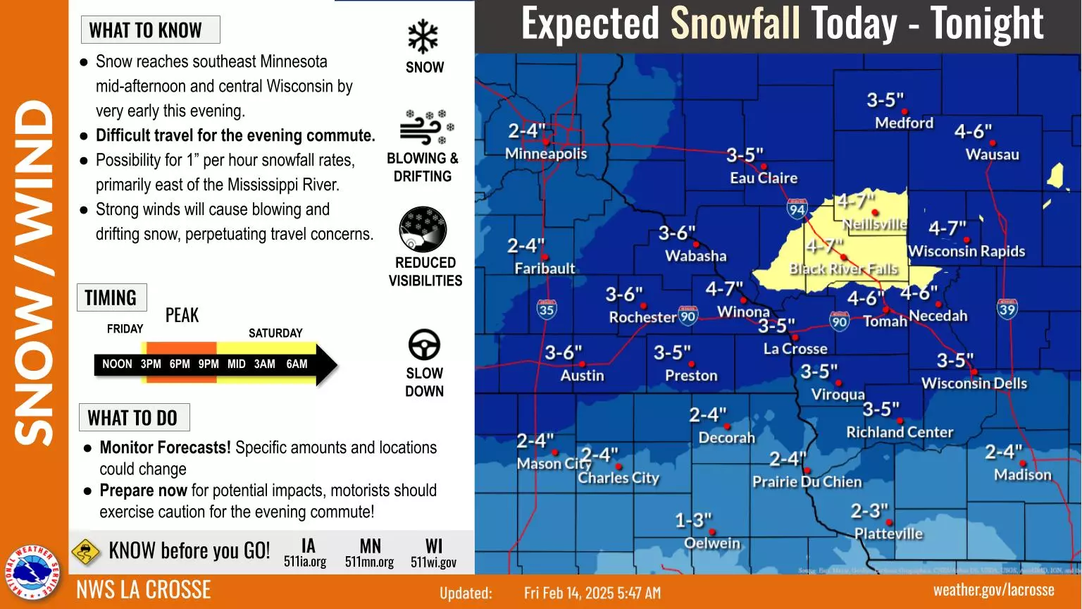
Forecasters with the National Weather Service are warning that snow will blanket the region starting Friday afternoon, with conditions expected to deteriorate rapidly during the evening commute.

"Snow overspreads the region this afternoon as conditions worsen from the late afternoon through the evening commute," NWS forecasters say. "Lighter snowfall overnight makes way to a second round of snow through Saturday morning primarily remaining south of Interstate 90," NWS continued.
How Much Snow is Expected on Friday in Minnesota, Wisconsin?
The most immediate concern is a more significant snow system set to impact the region Friday, February 14, into Saturday morning.
The Rochester area, Winona, and Austin will likely receive 3 to 6 inches, while snowfall totals of 4 to 7 inches are expected in some areas of western Wisconsin.
Strong winds will cause blowing and drifting snow, reducing visibility and making the Friday evening commute hazardous. Snowfall rates could reach 1 inch per hour, particularly east of the Mississippi River.
Additional Snow Saturday in SE Minnesota, Western Wisconsin
After the first round on Friday, another band of light snow is forecast for Saturday, February 15, with accumulations of 1 to 2 inches for most areas, including Rochester, La Crosse, and Winona.
Though snowfall amounts will be lighter compared to Friday, slick roads are anticipated. Motorists should plan for slower travel and monitor forecasts as the storm track could shift.

Dangerous Cold Returns to SE Minnesota, Wisconsin
After all of the snowfall is said and done, a wave of dangerously cold temperatures is set to sweep across the area from Sunday (2/16) through Tuesday (2/18).
Wind chills as low as -30 to -40 degrees Fahrenheit are expected in many locations, including Rochester, Austin, La Crosse, and Decorah.

"Cold air spreads across the area Saturday night, making way for below zero overnight minimum temperatures Sunday night through Thursday," NWS La Crosse says. "Resultant wind chills will plummet near 35 below zero during the start of the new week. Coldest nights are forecasted overnight Sunday into Monday morning and overnight Monday into Tuesday morning."
Frostbite could occur in as little as 10 minutes under these conditions. Residents are advised to limit time outdoors, cover all exposed skin, and ensure pets are brought indoors.
Download our free mobile app to have the latest local weather updates sent directly to your phone.

BRRRR: The 15 Coldest Cities in America
Gallery Credit: Dunken
More From Y-105FM

![30 Kids Are Missing From Minnesota, Let’s Help Get Them Home [UPDATED]](http://townsquare.media/site/717/files/2021/04/attachment-Missing-Kids.jpg?w=980&q=75)