Snow Storm No More – Potential Snow Storm Shifts South Of Southeast Minnesota
Early Sunday morning it looked as if the snow was going to make its way to Southeast Minnesota, but it good ole Minnesota fashion, the forecast changed in a hurry.
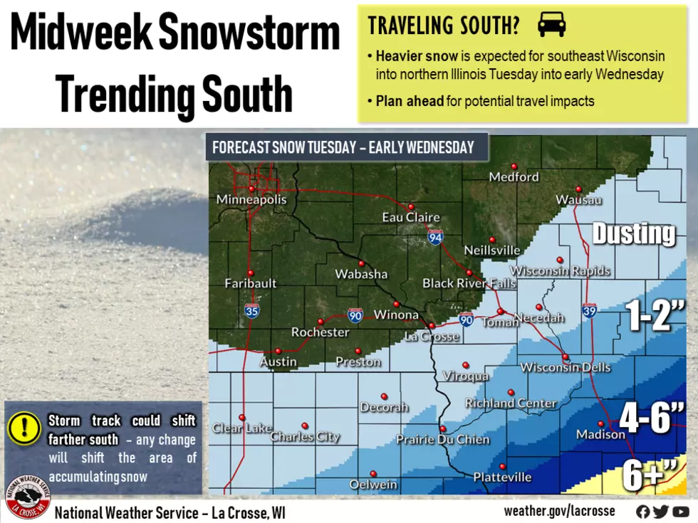
Indications are that the snowstorm will now move southeast of Minnesota and hit mostly in Southeast Wisconsin and Northern Illinois, according to NWS in La Crosse.
Minnesotans may see a dusting in the far Southeast portions of the state, but what initially looked like roughly four inches of snow, turned into basically none, especially north of the I-90 border.
If you are planning on traveling southeast of Minnesota, be sure to give yourself plenty of time and plan on tough traveling conditions. There is an expectation of a cool down later this week.

A year ago today it was a historic snowstorm across the area that dumped over a foot of snow across the area. Here is what the National Weather Service said about the storm on February 23-24 2019:
"The heaviest snows, in places over a foot, fell along an Austin, MN to the Medford, WI line. The snow came down fast, from 1 to 3" per hour at times. The bulk of the accumulations occurred by 6 am Sunday for locations south of I-94, lingering further north through the noon hour.
As the snow was ending, winds started ramping up. Sustained northwest winds around 30 mph were common across the open areas of southern Minnesota and northeast Iowa - gusting upwards of 55 mph! These winds spread east into western Wisconsin later in the morning, persisting through the afternoon. The strong winds and heavy snow created blizzard conditions and major drifting across much of northeast Iowa, southeast Minnesota and into north-central Wisconsin. White-outs in open areas were common. There were numerous road closures (including Interstate 90) along with some tow bans."
It was a nasty storm and caused many roads to close and affected much of Southeast Minnesota, Northeast Iowa, and Southwest Wisconsin.

More From Y-105FM